Al Beruni was a great Muslim scientist of the eleventh century who had knowledge of many diverse fields such as astronomy, astrology, mineralogy etc. He was member of Mahmud of Ghazni’s court from 1017 to 1030. It is here that he had the opportunity to travel to India (as well as present day Pakistan) and write about it in his books. It is claimed that he even learned Sanskrit during his stay in India. However, Al Beruni is most well known for his experiment to calculate the radius of the earth at a location close to Katas Raj in Kallar Kahar region of Pakistan. Some claim that the location of his measurements was in fact Nandana fort which is about 40 km east of Katas Raj temples.
His method of calculation involved two steps.
Step 1: Calculate the inclination angle of a mountain at two locations with known separation between them. We can then use simple trigonometry to find the height of the mountain. The trick here is to realize that there are two right angled triangles with the same height, which is an unknown, and base lengths which are also unknown but can be factored out (the reader is encouraged to do the math himself).
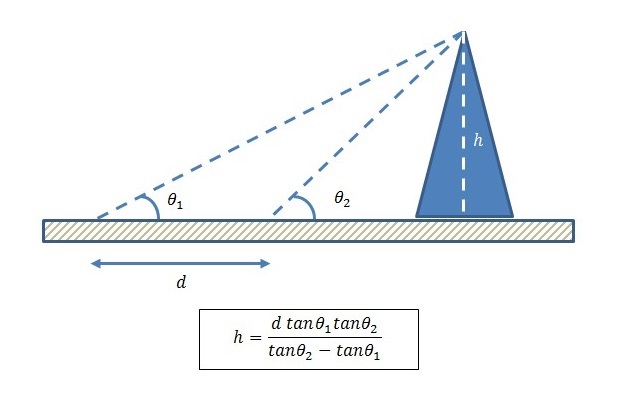
Figure 1: Calculating the Height of a Mountain
Step 2: The second step involves calculating the angle of depression that the horizon makes as viewed from top of the mountain. Then with the height of the mountain already known the radius of the earth can be easily calculated as shown below.
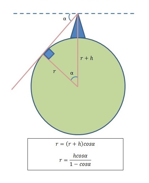
Figure 2: Calculating the Radius of the Earth
As the reader might have noticed there are three angular calculations and one distance calculation involved. Distance is easy to measure but angle is not and an accurate Astrolabe is required for this purpose. The Astrolabe that Al Beruni used was accurate to two decimal places of a degree. The radius that he calculated was within 1% of the accepted radius of the earth today.
PS: The writer has been to Katas Raj temples several times and it his desire to go there again to find more information about the location of the experiment and to possibly re-enact the experiment.
Note:
- A polymath is a person whose expertise spans a significant number of different subject areas; such a person is known to draw on complex bodies of knowledge to solve specific problems.
- An Astrolabe is an elaborate inclinometer, historically used by astronomers and navigators to measure the inclined position in the sky of a celestial body, day or night.
- Nandana was a fort built at strategic location on a hilly range on the eastern flanks of the Salt Range in Punjab Pakistan. Its ruins, including those of a town and a temple, are present. It was ruled by the Hindu Shahi kings until, in the early 11th century, Mahmud of Ghazni expelled them from Nandana.
Author: Yasir
More than 20 years of experience in various organizations in Pakistan, the USA, and Europe. Worked with the Mobile and Portable Radio Group (MPRG) of Virginia Tech and Qualcomm USA and was one of the first researchers to propose Space Time Block Codes for eight transmit antennas. Have publsihed a book “Recipes for Communication and Signal Processing” through Springer Nature.
3 thoughts on “Al Beruni’s Method for Calculation of Radius of Earth”
Thank you, Yasir, for great information.
Jamil
Hi There John
Good information; i would like to get in touch
Rizwan Buttar
Nice work